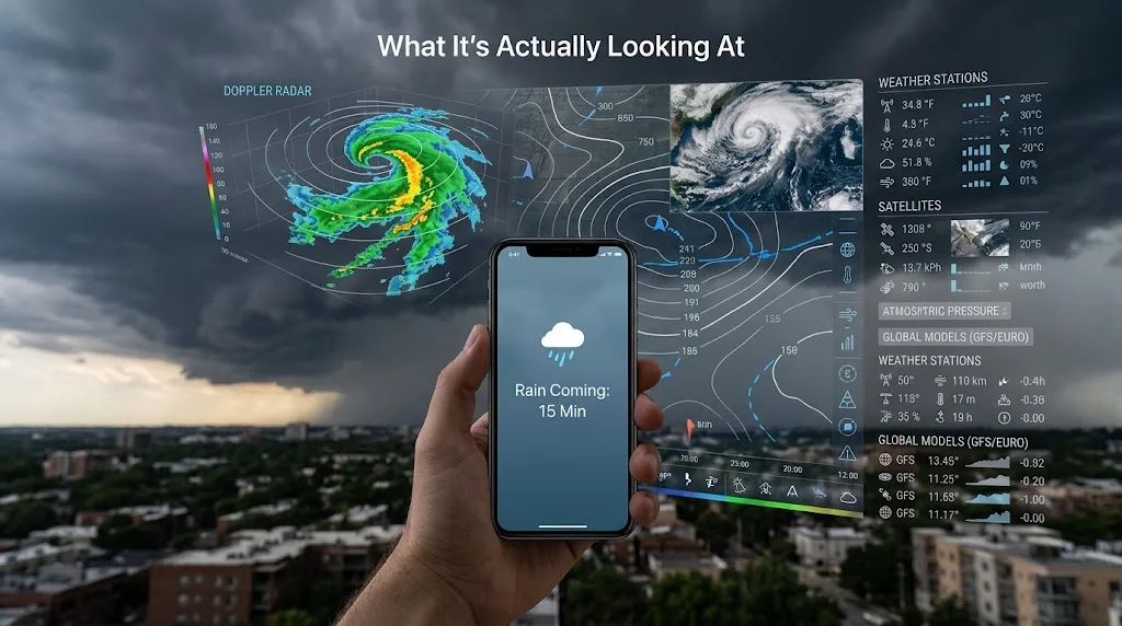
You check your weather app before leaving home and it says rain is coming in about an hour. The sky outside may still be bright and dry. There may not even be a cloud overhead.
A little later, the clouds arrive.
Your phone didn't see the rain with its own eyes. It didn't know what was going to happen in the future. What it had was a huge amount of information about what was happening in the atmosphere right now, combined with computer models that calculate how those conditions are likely to change.
Weather apps are basically the last step in a much larger forecasting system.
The information begins with satellites, radar, weather stations, balloons, aircraft, ships and other observing systems. Those measurements are combined to estimate the current state of the atmosphere. Forecast models then use physics and mathematics to calculate possible future conditions. The weather app takes the resulting forecast and turns it into something you can understand at a glance.
So when your phone says rain is coming, it isn't making a guess from a single satellite image. It's the end product of a long chain of measurements and calculations.
Where does the weather data come from?
There isn't one giant weather sensor somewhere taking a picture of the whole planet.
Weather services collect observations from many different systems.
Weather stations measure things such as temperature, pressure, humidity and wind. Weather balloons carry instruments high into the atmosphere and measure conditions at different heights. Aircraft provide observations while flying. Ships and ocean buoys provide information over the water, where there are far fewer ordinary weather stations.
Then there are satellites.
Modern weather forecasting depends heavily on satellite observations because huge parts of the Earth have relatively few surface observations, particularly oceans and remote regions. ECMWF says its forecasting system processes observations from dozens of satellite instruments alongside surface-based and other measurements.
Radar adds another kind of information, especially when rain is already developing.
All of these sources are useful because they measure different parts of the atmosphere. A satellite can observe enormous areas. A weather station can provide detailed conditions at a particular location. Radar can track precipitation. A balloon can measure what is happening higher in the atmosphere.
The forecast becomes much better when those pieces are considered together.
Do weather apps actually use satellites?
Yes, but probably not in the way you imagine.
A satellite isn't simply taking a photograph of a cloud and sending your phone a message saying, "Rain in 45 minutes."
Weather satellites carry instruments that measure different forms of radiation coming from the Earth and atmosphere. Those measurements can provide information about clouds, temperature, moisture and other atmospheric conditions.
That information is especially valuable over areas where there aren't many conventional weather observations.
The measurements don't go straight from the satellite to your weather app. They are processed and combined with other observations. Forecasting centres use a process called data assimilation to build the best possible estimate of what the atmosphere looks like at a particular moment.
That starting picture matters enormously.
If the forecast model begins with the wrong temperature, moisture level, pressure pattern or location of a weather system, the error can grow as the forecast moves forward.
This is one reason weather forecasting is difficult. The atmosphere is constantly changing, and you can never measure every part of it perfectly.
What does weather radar actually do?
Radar is particularly useful for answering a different question:
Where is precipitation right now, and where does it appear to be moving?
Weather radar sends out radio waves and listens for energy reflected back from objects in the atmosphere. Raindrops, snowflakes and other particles can reflect some of that energy.
By processing those returning signals, meteorological systems can determine where precipitation is occurring and gather information about its movement and intensity.
That makes radar extremely useful when rain is already developing.
Imagine a line of showers moving toward your city. A forecast model may have predicted that showers were possible this afternoon. Radar can now show that precipitation has actually formed, where it is, and how it is moving.
The app can use that newer information to update the short-term forecast.
This is why a rain prediction for the next hour can be based on a different kind of information from a prediction for next weekend.
For very short time periods, observing what is already happening can be extremely useful. For longer periods, the forecast depends much more heavily on numerical weather prediction models and the larger atmospheric pattern.
So how does a computer predict rain that hasn't happened yet?
This is the part that sounds almost magical until you understand what the computer is actually doing.
Weather models divide the atmosphere into a huge three-dimensional grid. They use mathematical equations describing things such as air movement, temperature, pressure, moisture and other physical processes.
The model starts with the best estimate of the atmosphere's current condition.
Then it calculates what those conditions are likely to look like a short time later.
Then it calculates the next step.
And the next one.
And the next.
The result is a simulation of how the atmosphere could develop over hours and days.
NOAA describes numerical weather prediction models as computer programs that solve large numbers of equations for atmospheric conditions at different locations and heights.
The important word is could.
A forecast isn't a recording of the future. It's a prediction based on the information available when the forecast was produced.
That distinction explains a lot of what seems strange about weather apps.
Why can an app predict rain hours before there are clouds over you?
Because the rain doesn't begin with the first raindrop falling on your street.
The atmosphere may already contain the conditions that will produce rain.
A weather system can be moving toward your area. Moist air can be flowing into a region. A front can be approaching. Air can be rising and cooling. Clouds can be developing elsewhere along the same system.
The forecast model sees those larger patterns and calculates how they are likely to develop.
Radar and satellite observations can then provide additional evidence as the event gets closer.
So the app may say rain is coming while your immediate surroundings still look completely dry.
It's not predicting the rain from nothing. It's following a chain of atmospheric events that has already begun.
How does the app know what the weather will be at my house?
This is where things get a little less exact.
A weather forecast isn't necessarily produced specifically for your house.
Forecast models divide the atmosphere into grid cells. The actual model may represent an area that is much larger than your street. Forecast providers then process that information to produce forecasts for particular locations.
That means the forecast for your location is an estimate based on the surrounding atmospheric conditions and the forecast system's ability to represent local differences.
This becomes especially difficult with small-scale weather.
A large area of steady rain can be relatively straightforward to track. A group of thunderstorms is much harder.
One storm can dump heavy rain on one neighborhood and leave another neighborhood a few kilometres away almost completely dry.
The atmosphere doesn't care that both places have the same postcode.
Small differences in terrain, temperature, humidity, wind and storm development can change where a shower forms and where it moves.
That's one reason a forecast can be broadly correct while still being wrong about what happened in your particular street.
What does the percentage of rain actually mean?
This is one of the most misunderstood parts of a weather app.
If your app says 40% chance of rain, it does not simply mean that it will rain for 40% of the day.
It also does not mean that 40% of your city will get wet.
Probability of precipitation is defined as the likelihood of measurable precipitation occurring at a particular point during a specified period. The National Weather Service, for example, defines measurable precipitation in its standard forecasts as at least 0.01 inch.
So a 40% forecast is essentially saying that, for the specified location and time period, there is a 40% probability of measurable precipitation under that forecast definition.
The exact way different apps calculate and display precipitation probabilities can vary because consumer weather services use different forecast systems, data sources and processing methods.
But the number is a probability, not a promise that rain will occupy 40% of your afternoon.
Why can it rain in one neighborhood but not another?
Because rain isn't always produced by one enormous sheet moving across the landscape.
Showers and thunderstorms can be surprisingly local.
A storm may develop over one part of a city and weaken before reaching another. Another storm can form a few kilometres away.
This is particularly difficult for computer models because small weather systems can be smaller than the model's effective resolution.
A forecast might correctly recognize that the atmosphere is capable of producing thunderstorms in an area without knowing exactly which street will get the heaviest rain.
That is also why a forecast can say "40% chance of rain" while someone a few kilometres away gets soaked and you don't see a drop.
The forecast was expressing uncertainty about what would happen at that location.
Why do two weather apps sometimes disagree?
Because there isn't one single computer forecast that every weather app uses.
Different weather services can use different numerical weather prediction models, different observations, different update schedules, different ways of processing the model output and different methods of presenting the result.
Even when two services use some of the same underlying data, their final forecasts can differ.
Current weather-app explainers identify different models, update times, geographic processing and display methods as common reasons for disagreement.
There is another reason: the atmosphere itself is uncertain.
ECMWF describes the atmosphere as chaotic, meaning that small differences in the starting state can eventually produce significantly different outcomes. To deal with that uncertainty, forecasting centres can run ensembles, which involve multiple forecasts made with slightly different starting conditions or model configurations.
If those forecasts stay close together, the system has more agreement about what might happen.
If they spread apart, there is more uncertainty.
Your weather app may hide all of that complexity behind one little cloud icon.
Why does the forecast keep changing?
Because the atmosphere is changing, and the forecast is being recalculated.
New satellite observations arrive.
New radar observations arrive.
Weather stations report new conditions.
Aircraft, balloons, ships and other observing systems provide more measurements.
Then forecasting systems run new model calculations using the updated information. ECMWF describes this as a repeated process in which observations are compared with the previous model state and used to update the starting conditions for a new forecast.
Suppose a storm is moving slightly faster than expected.
The next forecast run gets information showing that the storm is farther along than the previous model predicted.
The predicted arrival time at your location may then move forward.
Your app didn't suddenly become bad at forecasting.
It received new information and changed its estimate.
Why are weather apps sometimes wrong?
Because predicting the atmosphere is an enormous information problem.
The atmosphere is three-dimensional and constantly moving. Measurements are incomplete. Weather systems interact with each other. Small errors in the starting conditions can grow with time.
The problem becomes especially obvious with small thunderstorms and showers.
A model might correctly predict an unstable atmosphere and a high chance of thunderstorms across a region. What it may not be able to determine perfectly is which particular patch of air will produce the storm first.
That difference matters when you're standing outside waiting for rain.
A forecast can therefore be useful without being exact.
It may correctly predict that conditions are becoming favorable for rain while missing the exact timing or location of the shower.
Forecast uncertainty generally grows as you look farther into the future. That's why a forecast for the next hour is answering a different question from a forecast for next Tuesday.
How does the app know the temperature?
Temperature forecasts start with actual temperature observations.
Weather stations measure the temperature at their locations, while other observing systems provide information about the atmosphere at different heights and over areas where surface stations are scarce.
Those observations become part of the initial atmospheric analysis used by forecast models.
The model then calculates how temperature is likely to change.
Cloud cover, wind, moisture, incoming sunlight, the surface beneath the air and other atmospheric processes can all affect the result.
The number you see on your phone is therefore not simply a thermometer reading sent from the sky.
For a current temperature, it may be closely tied to observations. For tomorrow's temperature, it is a forecast of what the atmospheric conditions are expected to produce.
What happens when the app says rain is coming right now?
This is where several parts of the system can overlap.
The forecast model may already indicate that rain is likely.
Satellite observations may show developing clouds.
Radar may detect precipitation approaching.
New observations may then cause the forecast provider to adjust its estimate.
Some modern services also produce very short-range precipitation forecasts, often called nowcasts, using recent observations and movement of precipitation systems.
The closer the predicted event is, the more useful recent observations can become.
That's why the weather map on your phone can sometimes show a rain area moving toward you even while the longer-range forecast simply says "showers."
The two features are answering slightly different questions.
One is asking:
What is the atmosphere likely to do later?
The other is asking:
What is the precipitation already doing, and where is it likely to move next?
The weather app is the last link in a very long chain
When your phone shows a rain icon, there's a remarkable amount of information hiding behind that tiny symbol.
- Sensors around the world measure the atmosphere.
- Satellites observe huge areas of the Earth.
- Radar tracks precipitation.
- Weather stations measure conditions at the surface.
- Balloons and aircraft provide information higher in the atmosphere.
- Forecasting systems combine these observations to estimate the atmosphere's current state.
- Computer models then calculate how that atmosphere could evolve.
- New observations continually update the process.
A weather service takes all of that information and produces forecasts for particular locations and times.
Your app finally turns those forecasts into the simple things you actually see: a temperature, a rain percentage, a cloud icon, or a message saying rain is expected soon.
So your weather app doesn't really know that it's going to rain.
It knows what the atmosphere looks like now, it has observations of what's happening around you, and it has computer models calculating where those conditions are likely to lead.
Sometimes that calculation is remarkably close.
Sometimes a storm forms a few kilometres away and completely ruins the prediction for your street.
Both outcomes come from the same basic system. Weather forecasting isn't a crystal ball. It's an enormous, continuously updated attempt to work out what the atmosphere is going to do next.